“Lorem Ipsum is simply dummy text of the printing and typesetting industry. Lorem Ipsum has been the industry’s standard dummy text ever since the 1500s, when an unknown printer took a galley of type and scrambled it to make a type specimen book.”
xxxx | xxxx
Project Duration: 2024 – 2025
Other Partners:
Project Description
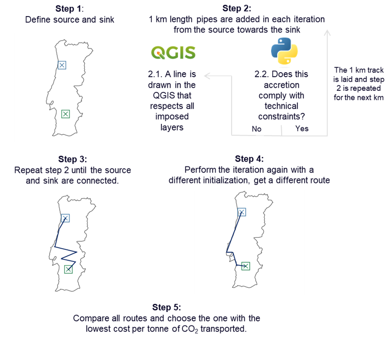
This project aims to develop a digital platform to support the optimized routing of CO₂ transportation pipelines using data from a Geographic Information System (GIS). In real-world scenarios, transporting CO₂ from an emission source to a storage or utilization site via pipeline requires careful consideration of multiple spatial, technical, and environmental constraints. The platform will integrate GIS-based geographic data—such as land use, elevation, protected areas, and existing infrastructure—to identify feasible corridors for pipeline construction. Using this data, an optimization algorithm will be developed and applied to determine the most cost-effective and technically viable route. The quality of each route will be evaluated based on factors such as total length, terrain, environmental sensitivity, and associated construction and operational costs. The final tool will provide a user-friendly interface that enables stakeholders to visualize and compare routing options interactively. Developed in collaboration with IPL, the platform is intended to address a real market demand for efficient CO₂ infrastructure planning.
Main Outcomes
Optimization Algorithm for Route Selection
Custom-built algorithm that determines the optimal pipeline path, minimizing costs and complying with technical and environmental constraints.
Interactive User Interface
Development of a visual and user-friendly interface allowing users to input parameters, visualize routes, and compare alternatives.
Cost and Risk Assessment Tool
Inclusion of a cost estimation module that considers construction complexity, terrain difficulty, and risk exposure along the selected route.